Who we are
Precise weather forecasts and personal consultation for safe decisions at sea and ashore.
Built on 27 years of experience.

40,00 € – 125,00 €
incl. VAT
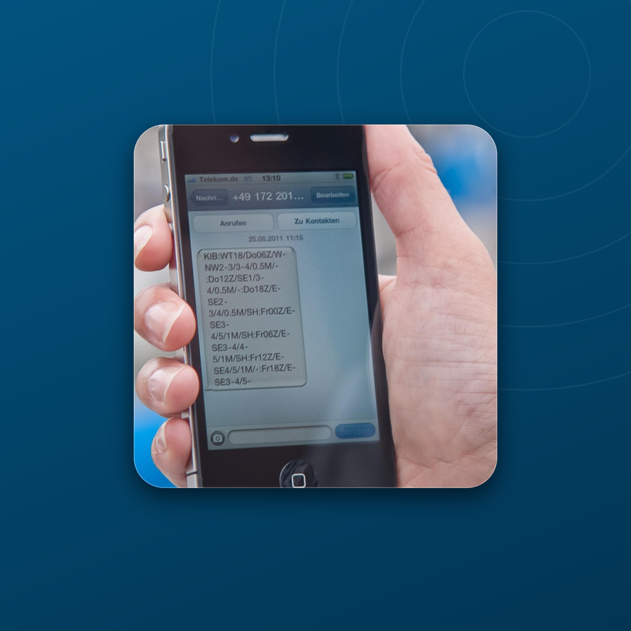
60-hour sea, land and route forecasts in six-hour steps by text message, with near-global coverage. One forecast is delivered as three messages and uses one credit; credit is valid for one year.
Already booked? Check your current credit.
60 HOURS BY TEXT MESSAGE.
The SMS Weather Service provides 60-hour sea and land forecasts in six-hour steps with near-global coverage. Request a regional or coordinate-based forecast, or route weather from your current position.
One forecast is delivered as three reply messages and uses one credit. Request forecasts at any time or arrange automatic delivery for a predefined area up to twice daily. Your mobile provider may charge for the outgoing request message.
Credit is valid for one year from activation. Remaining units carry over only if you top up before expiry; otherwise they expire. Satellite and Iridium phones are not supported.
THE UNCOMPLICATED WAY.
Send a three-letter area code or geographic coordinates to +49 160 633 6401. Area codes are not case-sensitive.
Send your position, course in degrees and speed in knots. The projected track is calculated and answered with a 60-hour forecast.
Request forecasts yourself around the clock. You can also arrange automatic delivery for an agreed area up to twice daily.
Sea weather includes wind, gusts, wave height and weather conditions. Land weather includes wind, pressure, temperature and weather conditions, all in six-hour steps.
Credit is valid for one year from activation. Remaining units carry over only if you top up before expiry. An information message is sent before expiry and below ten units.
Requests work over mobile networks when text messages can be sent to the German request number. Satellite and Iridium phones are not supported.
Once activated, send your request from your registered mobile number to
+49 160 633 6401
For an area forecast, send only the three-letter code, for example KIB for Kiel Bay. Do not add the area name or other text. One forecast uses one credit and arrives as three reply messages.
KIB
Kiel Bay
2808N 01523W
Las Palmas de Gran Canaria
5231N 01324E LAND
Berlin
3913N 00304E 63 05
Start near Mallorca, course 63°, speed 5 kn
Use degrees and minutes: four latitude digits followed by N/S, and five longitude digits followed by E/W. Keep leading zeros and spaces. Use the literal keyword LAND for land weather, also in English-language requests.
Choose your sailing area and use the code shown in the table. Codes are identical in both languages.
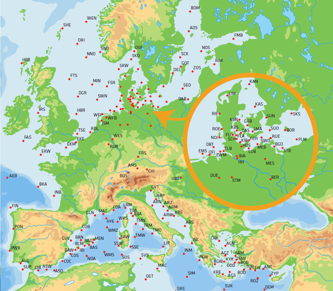
SMS area map. Area names and codes are listed in the tables below.
| Area | Code |
|---|---|
| Bay of Lübeck | LUB |
| Bay of Mecklenburg | MEB |
| Bornholm | BOR |
| Central Baltic Sea | ZOS |
| Central Polish coast | PLM |
| Danish South Funen Archipelago | DAS |
| Eastern Bodden waters | BGO |
| Eastern Swedish skerry coast | SCK |
| Fehmarn | FEH |
| Gotland | GOT |
| Great Belt | GRB |
| Gulf of Bothnia | BOM |
| Gulf of Finland | FMB |
| Gulf of Gdańsk | DAB |
| Gulf of Riga | RIM |
| Inner Flensburg Fjord | FLI |
| Kiel Bay | KIB |
| Northern Baltic Sea | NOS |
| Northern Kattegat | KAN |
| Northern Little Belt | KBN |
| Outer Flensburg Fjord | FLA |
| Rügen | RUE |
| Schlei | SCH |
| Småland waters | SMA |
| South coast of Sweden | SKS |
| Southeastern Baltic Sea | SEO |
| Southern Baltic Sea | SUO |
| Southern Kattegat | KAS |
| Southern Little Belt | KBS |
| Southwestern Baltic Sea | SWO |
| Szczecin Lagoon | STB |
| Åland Sea | ADS |
| Öland | OEL |
| Øresund | SUN |
| Area | Code |
|---|---|
| Central North Sea | MIN |
| Dogger | DGR |
| East Frisian Islands | OFI |
| Eastern Skagerrak | SKO |
| Elbe | ELB |
| Elbe and Weser estuaries | EWM |
| Ems estuary | EMS |
| Fischer | FSR |
| Forties | FTS |
| German Bight | DBT |
| Humber | HBR |
| IJsselmeer | JSM |
| Limfjord | LIM |
| North Frisian Islands | NOI |
| Northern North Sea | NNO |
| Orkney Islands | ORI |
| Oslofjord | OSF |
| Rhine delta | RDL |
| Ringkøbing Fjord | RIF |
| Rømø | ROE |
| Shetland Islands | SHE |
| Southwest coast of Norway | SNO |
| Southwestern North Sea | SWN |
| Thames | TSE |
| West coast of Norway | WEN |
| West Frisian Islands | WFI |
| Western Skagerrak | SKW |
| Area | Code |
|---|---|
| Algarve | ALG |
| Bay of Biscay | BKA |
| Central English Channel | EKM |
| Eastern English Channel | EKE |
| Fastnet | FAS |
| Finisterre | FIN |
| Hebrides | HEB |
| Inner Bay of Biscay | INB |
| Irish Sea | IRS |
| North coast of Portugal | PON |
| Outer Bay of Biscay | AEB |
| South coast of Portugal | SUP |
| West coast of Portugal | PWK |
| Western English Channel | EKW |
| Area | Code |
|---|---|
| Adriatic: Pula | ARP |
| Aeolian Islands | LIP |
| Antalya | ANT |
| Bodrum | BOD |
| Central Adriatic | ARZ |
| Central Aegean | AGZ |
| Central Balearic Islands | BLM |
| Chalkidiki | CHK |
| Costa Blanca | COS |
| Costa Brava | COB |
| Costa Cálida | COC |
| Crete | KRE |
| Cyclades | KYK |
| Cyprus | ZYP |
| Côte d’Azur | CDA |
| Dodecanese | DOD |
| Eastern Adriatic | ARE |
| Eastern Alboran Sea | ASO |
| Eastern Balearic Islands | BAO |
| Eastern Mediterranean | OEM |
| Eastern Tunisia | OET |
| Eastern Tyrrhenian Sea | TMO |
| Elba | EBA |
| Finike | FIK |
| Gibraltar | GIB |
| Gulf of Lion | GLN |
| Gulf of Sidra | GRS |
| Gulf of Trieste | GVT |
| Gulf of Valencia | GVV |
| Hyères | HYE |
| Ibiza | IBI |
| Ionian Sea | INM |
| Ionian Sea: Corfu | INC |
| Ligurian Sea | LRM |
| Malta Channel | MAC |
| Marseille / Toulon | MAT |
| Menorca | MEN |
| Middle Adriatic | ARM |
| North of Algeria | NOA |
| Northern Adriatic | ARN |
| Northern Aegean | AGN |
| Northern Balearic Islands | BAN |
| Northern Tyrrhenian Sea | TMN |
| Rhodes | ROD |
| Rhodes to Cyprus | ROZ |
| Samos | SAM |
| South of Crete | SUK |
| South of Sardinia | SUS |
| Southeast of Sardinia | SSE |
| Southern Adriatic | ARS |
| Southern Aegean | AGS |
| Southern Balearic Islands | BAS |
| Southern Ionian Sea | SIM |
| Southwest of Sardinia | SSW |
| Southwestern Mediterranean | WMS |
| Strait of Sicily | SVS |
| Turkish Riviera | TUR |
| Tuscan Archipelago | TOA |
| Tyrrhenian Sea | TRM |
| West coast of Turkey | TUW |
| West of Corsica | WKS |
| West of Sardinia | SAW |
| West of the Peloponnese | PEW |
| West-central Mediterranean | WMZ |
| Western Adriatic | ARW |
| Western Aegean | AGW |
| Western Alboran Sea | ASW |
| Western Balearic Islands | BAW |
| Western Tyrrhenian Sea | TMW |
| Area | Code |
|---|---|
| Ammersee / Lake Starnberg | AMS |
| Berlin lakes | BER |
| Binnenalster | BIA |
| Chiemsee | CHI |
| Dümmer | DUE |
| Franconian lakes | FRS |
| Holstein lakes | HOS |
| Lake Balaton, Hungary | UBT |
| Lake Constance | BOS |
| Mecklenburg Lake District | MES |
| Rur reservoir | RUR |
| Steinhuder Meer | STM |
| West Frisian inland waters | WFB |
| Westphalian lakes | WES |
Area list from the WetterWelt SMS flyer. Cannot find a suitable area? Request a forecast using coordinates.
THREE QUOTAS.
40,00 €
incl. VAT, that is 1,14 € per forecast
Remaining credit carries over when you top up before expiry.
75,00 €
incl. VAT, that is 1,14 € per forecast
Remaining credit carries over when you top up before expiry.
125,00 €
incl. VAT, that is 1,09 € per forecast
Remaining credit carries over when you top up before expiry.
| Forecast package | 35 forecasts, 66 forecasts, 115 forecasts |
|---|